
Ever find yourself wondering just how long those courteous travelers were really stranded on the Orient Express? Or wondering how far a carriage would travel from London to Longbourn? If so, here’s a tip you might appreciate.
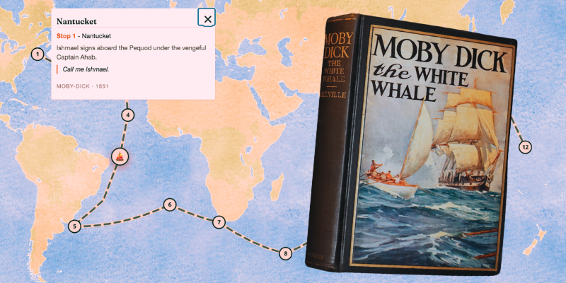
Reading Maps is home to an interactive database that invites curious readers to explore—perhaps even recreate—famous journeys drawn from literature.
These excursions are organized by mode (overland, sea) and by type (survival, exile, coming of age). The collection features road-tripping examples, such as the one depicted in Dave Eggers’ Heartbreaking Work of Staggering Genius, as well as cross-border emigration tales like Homegoing by Yaa Gyasi.
The project grew from the idea of Aires Loutsaris—an SEO consultant based in the UK by day, and a whimsical cartographer by night. Over several years, Loutsaris has built a free, interactive atlas that spans grand intercontinental epics (think Moby Dick) as well as intimate strolls like Mrs. Dalloway.
He joined forces with the site’s developer, Fabio Moreira, drawn by a wish for stakes that reach beyond the page.
“Odysseus crossed a real sea. The Pequod sailed real waters. Phileas Fogg’s eighty days ran on real railways,” Loutsaris writes on his source of inspiration. “However when you read a book, all that geography stays locked in your head. Once you close the cover, it goes with it.”
Enter Reading Maps, a meticulously crafted piece of fan service. On the site, readers can request a route from their favorite novel (or even a film!), and the team will set to work turning it into something tangible.
From a process standpoint, map-making begins with a close reading. Loutsaris first approaches a text by identifying stations and sequence, then tests his proposed coordinates against existing high-resolution base maps.
When a book’s setting is imaginary (as in Calvino’s Invisible Cities), he employs a system: anchor a hypothetical locale to “the nearest real location” and include an editorial note in the key.
Yet this modern Daedalus remains highly collaborative. He depends on readers to catch errors and suggest new sites for expansion—several did so for his map of Hemingway’s Moveable Feast.
Why maps? A visual aid can certainly scratch an itch, especially for those who long for the illustrations that often precede our favorite epics. But beyond the flair, maps provide a sense of scale that can be hard to grasp on the page.
After all, how long is Huck’s Mississippi River? It clocks in at about 875 kilometers, as it happens. And after tinkering with the interactive feature, I can say it lends a new feel for plot architecture—seeing at a glance how many miles separate Cairo from Memphis.
A map can also illuminate different characters’ motivations.
Experiencing Jonathan Harker’s long coach ride to Dracula’s castle is one thing. Seeing how the Count traversed the same path from Borgo Pass to Exeter by sea sharpens the contrast between these figures and hints at the Count’s stubborn, inexorable nature.
For his part, Loutsaris is enthusiastic about the broader implications.
“The aggregate view is what’s most interesting,” he told me by email. “You can observe where the canon clusters—the Mediterranean, the North Atlantic, the Silk Road—and the vast regions that fiction has barely touched.” Which only underscores the case for submitting those requests.
Although Reading Maps does carry a slight canon bias—“The Odyssey” has been the most requested “by a long shot,” as Loutsaris explained—the site’s charm lies in its welcoming, open-door policy. Nothing is too odd or too specific to plot.
Loutsaris’ personal favorite map comes from a maritime adventure of the 1970s: Bernard Moitessier’s The Long Way.
“He was leading the first solo non-stop race around the world in 1969 and kept going instead—bypassing the finish, circling the Cape of Good Hope a second time, and then on to Tahiti,” the cartographer told me. “On the map you can see him simply not turning north. To me, that shape is the whole argument of the book.”
Talk about the real thing.